Infill Proposal: Difference between revisions
Created page with "Hello, I live at the house at 6 Cedar Close, Tadley. RG26 3SL. It is a 4-bedroom detatched property, built in the early 1970's as part of a set of 14 houses in the road. The house has a large garden. I would like to know whether it might be possible to obtain planning permission to build a second house or bungalow on the part of the garden to the east, as a completely new dwelling (with separate provision of all utilities gas, electricity, water etc, as a separate add..." |
No edit summary |
||
| Line 24: | Line 24: | ||
1. The area is part of a "conservation area": | 1. The area is part of a "conservation area": | ||
https://www.basingstoke.gov.uk/conservationappraisals#elem_33878 | |||
2. The tree has a Tree Preservation Order (TPO) on it. | 2. The tree has a Tree Preservation Order (TPO) on it. | ||
| Line 30: | Line 30: | ||
3. The site is close to AWE Aldermaston, and is within the maps of Policy SPS8 - Nuclear Installations – Aldermaston and Burghfield: | 3. The site is close to AWE Aldermaston, and is within the maps of Policy SPS8 - Nuclear Installations – Aldermaston and Burghfield: | ||
https://consult.basingstoke.gov.uk/consultation/local-plan-update-regulation-18/chapter/policy-sps8-nuclear-installations-%E2%80%93-aldermaston-and-burghfield | |||
Latest revision as of 10:56, 28 October 2024
Hello,
I live at the house at 6 Cedar Close, Tadley. RG26 3SL. It is a 4-bedroom detatched property, built in the early 1970's as part of a set of 14 houses in the road.
The house has a large garden.
I would like to know whether it might be possible to obtain planning permission to build a second house or bungalow on the part of the garden to the east, as a completely new dwelling (with separate provision of all utilities gas, electricity, water etc, as a separate address like 6b Cedar Close). I believe this is called an "infill".
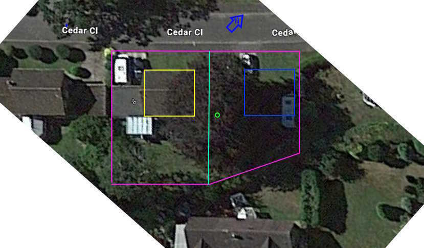
On the right is an annotated photo of the site, taken from Google Maps:

based on Google Maps at that location:
https://www.google.com/maps/@51.344836,-1.1307019,57m
In this photo, the boundary of the plot is shown in pink, and the existing house is the yellow square. The trunk of the large copper beech tree that dominates the site, is shown in green. I would imagine that this tree is likely to need at the very least to be coppiced to create the aerial space for the new construction - its branches are already close to the existing house, covering part of its roof.
The blue square is the location for the proposed new house or bungalow, with the cyan line being my proposed boundary between the two plots.
There are at least three issues that are likely to be involved in the decision:
1. The area is part of a "conservation area":
https://www.basingstoke.gov.uk/conservationappraisals#elem_33878
2. The tree has a Tree Preservation Order (TPO) on it.
3. The site is close to AWE Aldermaston, and is within the maps of Policy SPS8 - Nuclear Installations – Aldermaston and Burghfield:
